Upper Missouri River Trip
June 12-20 1999
o Poetry, o Article from
the News-Enterprise, o Recipes
o More of Jack's favorite photo's, o Bob and
Ella Mae Wade's collection.
o Fred's Journal and Devotions
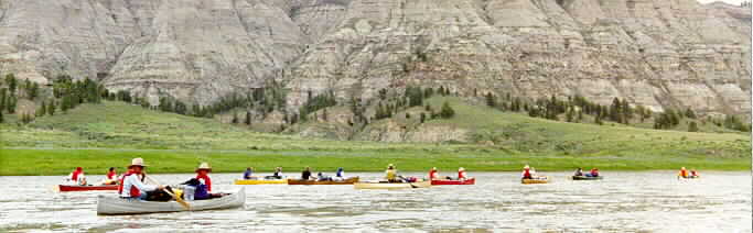
| Glenn Monahan's web site. http://www.roweweb.com/riverguides/ Click on photo for detailed view. ------------------->>>> Sunday afternoon June 13 receiving instructions from our guide, Glenn Monahan, about 1:00pm. Jack is listening attentively.
|
 "You must dig at least 6 to 8 inches" |
| Glenn is studying the map with Fred at the lunch stop, about 1:30 to 2:00. The teepee rings are up on the river bluff behind the camera. |  "Now which way is down river?" |
Day 1; June 13, 1999
shuttle from hotel at Great Falls
put in river at Coal Banks Landing
stop for lunch to visit Teepee Rings at top of river bluff
paddled about 13 miles
evening camp: across the river from white cliffs, near cottonwood grove
Day 2; June 14, 1999
hiking around the camp; some practice paddling for some of the campers
evening camp: same as Day 1
joined by friends from previous trip, guitar and recorder music around the camp fire
Day 3; June 15, 1999
lunch at "hole in the wall"
paddled about 13 miles
evening camp: about 70 L
hike to steamboat rock
Day 4: June 16, 1999
very windy paddling from 9:00 am to 5:00pm
stop at Judith landing about 4:30
paddled about 20 miles
evening camp: 90.5 R in large cottonwood grove
no facilities
Day 5; June 17, 1999
paddled 32 miles from 9:00 am to 5:00 pm
evening camp: 122.6 L
first mosquitoes
Day 6; June 18, 1999
visited homestead and hiked into badlands in morning
on river after lunch
paddled about 8 miles
evening camp: about 130 R
a few mosquitoes but not as many as Day 5 camp, first buffalo gnats
hike to look for dinosaur bones
Day 7; June 19, 1999
on river by 7:45; paddled about 19 miles
leave river at Kipp Landing, very muddy
shuttle back to hotel in Great Falls